Hello Geeks! It’s true that this year 2021 we have been a little less active than others, but last minute trips have changed a bit the plans we had. So, taking advantage of one of the last bits of good weather, we set off. This time we are going to visit the Längental, a valley in the Brauneck massif. It is just a stone’s throw from the villages of Bad Tölz and Lenggries, which we have already visited in the past. It is impressive that after almost 10 years in Bavaria, there are still such impressive places like this one, so close to home. I have the impression that the list is endless.
How to get to the Längental
To get to the Längental, I recommend driving to the address given here:
Vorderer Wanderparkplatz Längental
Längentalstraße, 83646 WackersbergCoordinates
47.701926158182964, 11.527729898079144
Here I would like to emphasise something important. Many of the blogs I consulted for this route mentioned the existence of a second car park, 1.5 kilometres from the one indicated above. However, this car park is not available at the time of writing. In mid-2020 a barrier was put up and closed to visitors. This increases the total length of the route from about 7 kilometres to just over 10 kilometres. If you have slightly younger children, you should take this into account.
The second car park is NOT available, so we will have to park in the first car park
If, in any case, you want to come by public transport, you can take the train to Obergries (stop before Lenggries). However, from here to the starting point of the route you have to walk quite a distance. About 4 kilometres extra in each direction should be added, so that we are almost at the 20-kilometre mark. Definitely not suitable for younger children.
Description of the route
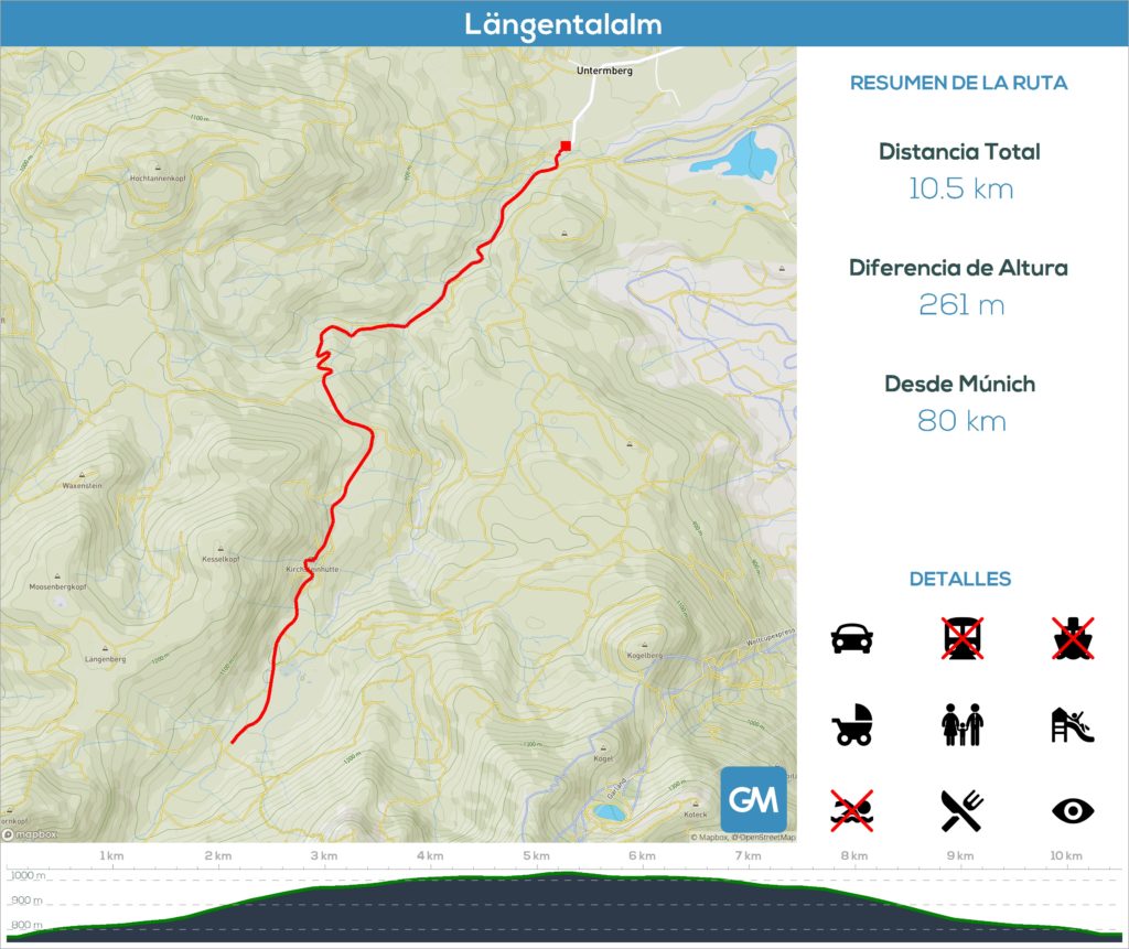
In the following infographic you can see the most important details of the route to Längental. Here you have to take into account the fact that we mentioned about the second car park. This makes the route considerably longer than many other blogs indicate
In total, just over 10 kilometres, with an elevation difference of less than 300m. This difference is over a section of just over a kilometre, so there is a fairly steep section. The rest of the route is practically flat, but you have to get to the top
It is a forest track suitable for cars, so we can bring our pushchair with us without any problems. The only thing is that, as we have mentioned, there are parts where you will need a lot of stamina
As a recommendation, always stay on the track, and ignore the shortcuts you might find, as some of them are quite steep and slippery. And when it comes down to it, it doesn’t get much shorter either, because the uphill and/or downhill pace suffers considerably.
Refreshments
Along the route, we can enjoy two places where we can stop for a drink. In our case, we decided to stop at the first of the huts Kirchsteinhütte. Once we are in the valley proper, it is located halfway. As the valley was completely shrouded in fog and the temperature did not rise above 6 degrees Celsius, a technical stop for a hot chocolate is a must!
We can also continue on to the second hut, the Hintere Längentalalm, just over a kilometre from the first and the end of the route. The views from here over the entire mountain massif are breathtaking.
Be aware that Google Maps has the wrong location for both huts, and places them in the wrong places. Be warned!
Video chronicle
Video chronicle of our adventure to Längental, for you to enjoy in 4K:
Photo Gallery
As usual, here are a few photos for you to enjoy the surroundings. The fog overshadowed some of the views for most of the day, but even so, it wasn’t too bad:


